|
|
|
|
|
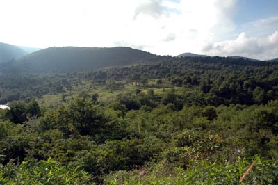
View of Graveyard Fields |
|
Blue Ridge Parkway |
|
|
|
|
|
View of Graveyard Fields |
|
Blue Ridge Parkway |
| Graveyard Fields Trail is one of the great hiking opportunities that can be found on the Blue Ridge Parkway. From the parking lot you get a feel for some of the great photo opportunities it has to offer as you look across the desolate fields lined with the occasional trees. The trail to the base of the lower falls is almost all down hill. Heading down the stairs from the parking lot a canopy covered paved trail beckons the hiker into the unknown. It curves and twists leaving one to wonder when you will reach the end. The paved trail ends and the fun now commences, this part of the trail is root and rock covered and often muddy. It is still surrounded by rhododendrons but there is no longer the canopy overhead. The water is getting louder, and then at the bottom of the hill two bridges provide a way for the hiker to cross the stream that leads to Lower Yellowstone Falls. After the bridge, a decision awaits – left or right. If you turn right, the trail crosses a little stream, which is easily crossed by hopping across rocks. Afterwards climb up some a couple of steps and then climb down a long staircase and there is an overlook from which to view Lower Yellowstone Falls. After viewing the falls, take a deep breath and head back up hill back to the parking lot. However, if you choose to go left at the bridge, you will head up a hill, then continue on thru the field that is viewed from the parking lot. This is the hiking trail that heads toward Upper Yellowstone Falls. It offers several places to stop and relax by the stream and if hiking this trail during the autumn - the trail is dotted with bright red foliage and the trees provide a rainbow of orange, red, and purple. | |
|
|
|
| Activities: | Hiking, Photography, Camping |
| Location: | Blue Ridge Parkway, North Carolina |
| Directions: | Take the Blue Ridge Parkway to mile marker 418.8, which is located between Rt. 215 (Rosman) and Rt. 276 (Brevard) |
| Trails: | Graveyard Fields Trail |
| Topography: | Rivers, fields, waterfalls |
| Hiking Information: | Trail can be muddy |
| Trail Map: | Trail map is located on wooden sign at parking lot |
| Photo Album: | Other Photographs |
Return to Southeast Hiking Main Page
Page Updated:January 30, 2005